A Two-County Map Afternoon: Compare One Route at Two Scales
A two-county map afternoon helps you trace a route from neighborhood streets to the wider county network and see what each map scale reveals.
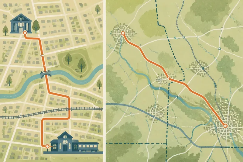
A two-county map afternoon can show why a route that looks simple on neighborhood streets may matter differently across a county. Choose one familiar connection—a road between two towns, a bus corridor, or a path linking a village to a larger center—and follow it at two scales. The purpose is not to find the fastest way or settle a boundary question. It is to notice what each map makes legible, and what it pushes beyond the edge.
Choose a route with a clear local purpose
Start with a connection you can describe without consulting a map: the road people take from a residential area to a station, the street that joins a school district to a town center, or a route between two settlements on opposite sides of a county line. A route with a recognizable beginning and destination gives your eyes something to follow.
Keep the route modest. A long journey can cross too many kinds of terrain and turn the activity into a survey of everything along the way. A short road or transit connection is easier to compare, especially if it passes through one built-up area before opening into countryside or another town.
Write down the starting place, destination, and the reason the route connects them. “The county road from the library district to the rail station” is more useful than “the main road.” You do not need to know whether that description is official; it is a working description for reading the maps.
Gather maps that show different amounts of ground
Use two maps of the same general area. For the local view, choose a street map or detailed online map that shows intersections, blocks, streams, rail lines, and local roads. For the wider view, use a county map, regional road map, or online view zoomed out enough to show both counties and the settlements between them.
Try to keep the map sources consistent if you can. Different mapmakers may draw roads or label places differently, and those differences can distract from the scale comparison. If the two views come from separate sources, treat variations in labels and line styles as map choices rather than evidence that a road has changed.
- Check that the local map shows the route’s intersections and nearby landmarks; if it does, use it for tracing turns, but if it does not, choose a more detailed view.
- Check that the wider map includes both county outlines and the route’s larger context; if it does, use it for regional connections, but if it does not, zoom out or select another map.
- Check the map date or source when shown; if it is clear, note it beside your observations, but if it is absent, mark the map’s currency as unknown.
- Check whether screen panels or search boxes cover roads or boundaries; if they do, close or move them, but if they do not, leave the view unobstructed.
- Check whether both views come from the same map source; if they do, compare their labels directly, but if they do not, treat differences in names and line styles as source variations until landmarks clarify them.
- Check whether you have a place to record observations without obscuring the maps; if you do, keep notes there, but if you do not, use a blank sheet or a separate screen document.
A printed map works just as well as a screen. Place the views side by side rather than trying to align them perfectly.
Trace the route at neighborhood scale first
On the detailed map, locate the starting point and follow the connection toward its destination. Move slowly enough to notice each change in the route: a turn at an intersection, a bridge over a creek, a shift from numbered road to named street, or a transition from a compact grid to a winding road.
Do not assume that the boldest line is the route people use. A map may emphasize a highway while giving a smaller connector less visual weight. Follow the road itself, checking each junction, and note any point where the route could reasonably split in more than one direction.
Record only a few observations at this stage. You might note that the route passes a school, skirts a wooded tract, crosses a rail line, or meets a road that appears to continue toward another settlement. These landmarks will help you recognize the same corridor on the county view.
Say you begin near a neighborhood library and trace a road to a station just beyond a small town. You notice that the road crosses a creek, bends around a park, and meets a county road at the edge of town. Those details give you several points to look for when you zoom out.
Move outward without losing the route
Now find the same starting place and destination on the wider map. Trace the route again, this time allowing your attention to move beyond the pavement. Where does the connection sit among other towns, major roads, rail corridors, rivers, or county boundaries? Does it appear to feed into a larger route, or does it remain a local link between nearby places?
At this scale, a street name may disappear, and a small turn may become a single line. Use the landmarks you recorded—especially a creek crossing, rail line, or road junction—to confirm that you have found the same connection. If a landmark is too small to appear, follow the route’s general direction from one recognizable settlement or junction to another.
Look at what enters the frame as you zoom out. A county map may show that a route reaches across a county line, joins a road serving several towns, or connects a residential area to a regional center. It may also reveal that a nearby road offers another connection, even if the local map made your chosen route seem like the only one.
Compare what each scale makes visible
Place your notes from the two views side by side. The detailed map is usually better at showing turns, crossings, nearby land uses, and the route’s relationship to individual blocks. The county view is better at showing broader direction, neighboring settlements, administrative boundaries, and connections to major roads or transit corridors.
Neither view is complete. The local map can make the route feel self-contained because it crops out the places it eventually serves. The wider map can make it look direct and uncomplicated, even when the on-the-ground path bends around a creek or passes through several junctions.
Ask what changed in your description. If you first called the route “the road to the station,” perhaps the county view shows it is also the link between two towns. If you thought of it as a county road, the detailed view may show that people use only one short stretch to reach a school or shopping street. The shift in description is the main result of the exercise.
Keep the map reading grounded
A map represents selected features, not every condition a traveler would encounter. It may omit a private road, show a trail that is closed, or use a boundary line that is difficult to distinguish from another feature. For travel decisions, check current local information rather than treating a map-reading activity as route guidance.
Also separate what the map depicts from what you infer. A road crossing a county line is visible; the reason people use it, or whether it feels like a shared regional corridor, may not be. You can write down a question prompted by the map without turning it into a conclusion the map cannot support.
Questions that help compare the two views
Which landmarks help identify the route?
Look for crossings, junctions, rail lines, streams, parks, and distinctive street patterns. A small set of recognizable features makes it easier to match the local route with its broader representation.
Why does a route seem to change when I zoom out?
At a smaller scale, mapmakers simplify detail so the larger pattern remains readable. Local turns and minor roads may disappear, while the route’s direction and links to major roads become more prominent.
How should I handle different road names on the maps?
Compare the road’s position, junctions, and landmarks rather than relying on its label alone. Map sources may use abbreviated, alternate, or locally familiar names for the same connection.
Can I use a bus or walking route instead of a road?
Yes, provided both map views show enough of it to follow. A transit map may emphasize stops and service patterns, while a street map supplies the physical setting, so note which features come from which source.
Finish with a description that changes with scale
Write two short descriptions before you put the maps away. In one, describe what the route does locally: where it begins, what it passes, and where it meets its destination. In the other, describe its wider role: which settlements or county areas it links and what larger corridor it joins, if any.
Keep uncertainty visible. If a road appears to continue beyond the county line but the map label is unclear, say that it appears to connect rather than claiming more than the map shows. A careful description is more useful than an overconfident one.
This two-county map afternoon is easiest to repeat with a different kind of connection—a path to a river crossing, a bus line between county seats, or a road linking a small town to a neighboring service center. For the route you chose today, keep both scales in mind: one shows how the connection works on the ground, and the other shows whom and what it may bring together.