How a River Valley Organizes a County Landscape
A river valley organizes a county landscape by revealing changes in elevation, drainage, and settlement—without making the river a county boundary.
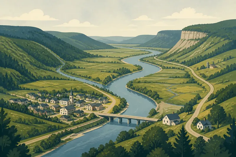
A river valley organizes a county landscape by linking high ground, tributary streams, and settlements along a shared drainage route. On a county map, that pattern can explain why slopes, roads, and communities change from one area to the next, even when the river itself stays well inside the county.
1. Read the valley as a sequence of elevations
Begin with the shape of the land, not the blue line marking the river. A valley usually has a lower corridor through its center, with higher ground rising on one or both sides. The change may be gradual, as on a broad plain, or abrupt where a river cuts between steep slopes. Either way, the river offers a reference point for reading relief across the county.
On a topographic map, contour lines curve around hills and often form repeated V shapes where they cross a stream. The pointed end of a V generally faces upstream, toward higher ground. Follow the contours away from the channel and note where they bunch together, indicating a steeper slope, or spread apart, suggesting gentler terrain. A shaded relief map can make these forms easier to see, while elevation contours help distinguish a real landform from a visual effect of shading.
Do not assume the valley is symmetrical. One side may rise gradually into rolling uplands while the opposite side climbs sharply to a ridge. Local geology, erosion, and the course of the river all contribute to that uneven profile. A countywide view can hide the difference, so compare the valley corridor with the slopes immediately beside it.
Use the channel as a starting line for tracing the land’s rise, not as a border between two equal halves.
2. Trace drainage from small streams to the main channel
A river’s route gathers water from a larger area than the channel itself. Small streams and ditches join it from the surrounding slopes; their combined drainage area forms a watershed. The watershed is a landform-defined area, separated from neighboring watersheds by higher ground. It may cross a county line, and a county may contain parts of several watersheds.
On a map, tributaries often resemble branches joining a trunk. Trace a minor stream uphill to see which slopes feed it, then follow its course downhill toward the larger river. Where ridges divide nearby streams, rain falling on opposite sides of the crest can flow in different directions. This branching pattern offers a practical way to understand which parts of a county are connected by surface water.
Water does not always travel in a tidy, visible channel. Wetlands, culverts, drainage ditches, and underground pipes may alter what appears on a general map. A stream line can also be intermittent, flowing mainly after rain or snowmelt. For local details, compare topographic mapping with current hydrography and land-cover maps; the map legend explains how each source represents streams and drainage features.
Say you are looking at an invented county map where a small creek enters the main river from the west. Trace the creek toward its headwaters and imagine the ridge between it and a neighboring eastern stream. The expected observable result is a clearer picture of which slopes drain toward the county’s main valley and which send water elsewhere, rather than an assumption that all nearby land shares one drainage route.
3. Notice where the valley floor widens or narrows
The valley floor is not a uniform strip beside the river. In some places, the channel runs close to a slope, leaving little flat ground. Elsewhere, the valley opens into a broad lowland that may include floodplain, terraces, wetlands, or fields. These shifts can explain why a road or settlement occupies one reach but not another.
A floodplain is low ground beside a river that can be inundated as water rises. Higher terraces may stand above it and show earlier levels of the river’s valley floor. On a contour map, a relatively flat area appears where elevation changes little across a broad space; the map alone may not establish how often that ground floods. Flood hazard maps and local planning information provide a separate view of potential inundation, and their categories should be read according to their legends.
Watch for bends, confluences, and changes in slope. A tributary entering the main channel can create a broader area of deposited sediment, while a narrow gorge may leave little room for a flat corridor. These features are clues, not a complete account of soil, water, or land use. The useful question is how the available ground changes along the river’s course.
Compare the width of the level land at several points, rather than treating the whole valley as one continuous floor.
4. Use settlement locations to read access to the valley
Settlements may gather near a river for access to water, transport, crossings, or relatively level ground, but proximity alone does not explain why a particular place grew. A town may sit on a terrace above the floodplain, at a confluence, near a bridge, or where a road descends from higher ground. Each location connects the valley to a different part of the county.
Compare the built-up area with the river corridor and nearby slopes. A settlement spread across a broad plain may have expanded along roads that follow the valley floor. A compact place near a narrow crossing may be organized around a bridge or a road junction. Another community may stand on a bench above the river, close enough to use the corridor but separated from its lowest ground.
Maps at different scales can make these relationships clearer. A county map shows the wider pattern of towns and routes; a larger-scale street map reveals the placement of neighborhoods, bridges, and side roads. Look for the physical connection between the built area and the valley rather than reading a town’s position as proof of a single cause.
Where settlements sit on higher ground beside a river, check whether roads descend to a crossing or continue along the slope. That distinction often clarifies how the community relates to the valley.
5. Follow routes that use, cross, or avoid the valley
Roads and rail lines respond to valley terrain in different ways. A route may follow the flatter corridor beside the river, cross it at a bridge, or climb out of it to connect with another drainage basin. These choices create a network that can be read against the land’s contours, without assuming that every road follows the easiest line.
Look for where routes converge near bridges or where a road leaves the river to climb a tributary valley. A bridge connects the two sides of a corridor, but the approaches may be shaped by steep banks, wetlands, or limited level ground. Elsewhere, a road may cross a ridge and descend into a neighboring valley, connecting communities that do not lie along the same river.
To understand a route, trace it beyond the county map’s edge. A river corridor may continue into another county, and the road beside it may serve a regional connection rather than a local one. This is a way to read movement through the landscape, not a reason to treat the river as the county’s edge.
6. Keep the river’s course separate from the county’s shape
A river can organize drainage and settlement while remaining entirely within a county. County boundaries are administrative lines; watersheds and valleys are physical features. Sometimes an administrative boundary follows a river, but that alignment is a separate fact to check on an official boundary map. On a county map, the river’s course may bend, branch, or cross roads without corresponding to the county outline.
When reading a map, identify the county boundary from its legend, then trace the river independently. Notice where the channel passes through the county interior, where tributaries join, and where roads cross. This simple separation prevents a familiar blue line from being mistaken for a jurisdictional divide.
The distinction matters when comparing maps, too. A drainage map groups land by where water flows; a county map groups it by administrative jurisdiction. A valley can connect places across a county line, while a single county can include land draining into more than one river system.
Questions that clarify a river valley map?
How can I tell which way a stream flows?
Use contour lines and the stream’s tributaries: contour V shapes generally point upstream, while tributaries join the channel as they flow downhill. Confirm the direction with elevation labels or a map that uses flow arrows, if available.
Is a river valley the same as a watershed?
No. A valley describes a lower corridor shaped by the land, while a watershed is the area that drains toward a particular outlet. The two are related, but a watershed can include several valleys and may extend beyond the county.
Why is a town near a river but not on its bank?
It may occupy higher, flatter ground beside the floodplain, or connect to the channel by a road or crossing. Its position can reflect several local conditions, so compare the settlement with the valley floor, slopes, and nearby routes.
Does the river mark the county line?
Not by itself. Check an official county boundary map to establish the jurisdictional line, then compare it with the river’s course; the two may meet in places without being identical throughout.
Use the valley as a guide, not a boundary
To make sense of a county landscape, follow the river from its headwaters toward its larger channel, noting rising slopes, tributary junctions, flatter reaches, settlements, and crossings. Then check the county outline separately. This reading makes the river useful as a geographic guide: it reveals how land and water connect places, while leaving administrative boundaries where the map actually places them.
For a final check, compare one stretch of the river on a topographic map with the same area on a county road map. The first shows the shape and drainage of the land; the second shows how communities and routes fit within the county. Keeping those views distinct makes the valley easier to understand without assigning the river a boundary it may not have.