County Line or Familiar Region: Two Different Maps
County boundaries and familiar regions answer different questions. Learn which map to use for services, identity, local comparisons, and clear directions.
A county line can put a house in one jurisdiction while its residents identify with a region that crosses into the next county. County boundaries and familiar regions describe different kinds of belonging, so the useful map depends on the question you need answered.
That distinction matters when checking which office serves an address, describing a community, or explaining why neighboring towns feel connected. Start with the purpose of the map, not with the assumption that one boundary must explain everything.
A county boundary identifies an administrative area
A county boundary marks territory assigned to a county as an administrative unit. Depending on local arrangements, that unit may matter for government offices, courts, property records, elections, or public services. The boundary answers a specific question: which county contains this location?
It does not necessarily show how residents describe their community or where they go for work, shopping, school, or recreation. Streets on opposite sides of a county line may share the same daily routines without sharing the same county designation.
For an official matter, use the record or map produced for that purpose. A general county map can help you get oriented, but an agency’s current information may be needed to confirm which jurisdiction applies.
A familiar region describes shared connections
A familiar region is an area people recognize through landscape, local custom, history, or recurring connections. Its edges may be indistinct because those ties can grow weaker gradually rather than stop at a surveyed line.
Someone might describe a town as part of a coastal region because it shares a working waterfront and visitor routes with nearby towns. Another resident might use the same regional name more narrowly. Both descriptions can make sense if they reflect different connections, rather than competing claims about a legal boundary.
Regional identity can also reflect everyday travel. Residents may visit a neighboring county for work, health care, markets, or recreation and consider those destinations part of their wider home area. In that use, the region describes association, not official assignment.
The maps differ because they answer different questions
An administrative map sorts territory into defined units. A regional map communicates identity or a pattern of relationships. The county boundary is meant to be identifiable; a familiar region may have several plausible edges depending on who is speaking and what connection they have in mind.
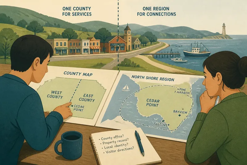
Imagine a fictional town called Cedar Point. Its county line runs just east of the town center, while residents commonly associate it with the North Shore, a region that also includes towns in the next county. If someone needs to identify the county office for an address, the county map is the relevant starting point. If they are explaining which towns share a shoreline and weekend market, the regional name may be more useful.
Neither map is necessarily wrong. Confusion starts when someone treats a regional label as proof of jurisdiction, or expects a county map to capture every sense of local identity.
Choose a map according to the question
A county map is generally better for questions about formal jurisdiction. A familiar-region map may be more useful for describing identity, shared destinations, or a wider local setting. For a specific address, check the source that governs the decision rather than relying on a broad regional label.
- County office or court: Check the official information for the address. If it identifies the county, use that county’s office; if it does not, contact the relevant agency before acting.
- Property record: Look up the parcel in the appropriate government record. If the record identifies a county, use that jurisdiction; if the address or parcel details conflict, ask the recording office to clarify.
- Local identity: Ask residents what they mean by the regional name. If they refer to shared landscape or community ties, describe it as an association; if they mean an official program area, name the program and its boundaries.
- Visitor directions: Name the county when jurisdiction matters. If the regional name helps orient the visitor, include it as an additional description; if it could send them to the wrong place, give a specific town or destination instead.
- Place comparisons: Compare counties with counties or regions with regions. If the areas differ in scale, explain that the regional area crosses county lines rather than presenting the comparison as equivalent.
- Unclear map shading: Read the legend and source. If the shading is identified as an administrative boundary, use it for that stated purpose; if the map gives no definition, treat it as an illustration and check a more authoritative source.
A clear description can name both levels: “Cedar Point is in East County and is commonly associated with the North Shore.” The wording distinguishes formal location from wider regional identity.
Read a map’s labels and purpose before relying on it
Look at the legend, labels, and source. A solid line marked as a county boundary has a different status from a shaded area labeled with a regional name. If the map does not explain what its regional shading means, treat it as an illustration of association rather than a formal boundary.
The map’s purpose also matters. A tourism map may group places to help visitors plan, while a government map may show administrative divisions. Neither is automatically the right source for every question. When a decision depends on an official boundary, consult the relevant agency or applicable local rules; for legal matters, seek qualified professional guidance where needed.
When a region’s edge is uncertain, use phrasing such as “often considered part of,” “associated with,” or “near the edge of.” That describes a flexible identity without turning it into a surveyed line.
How do county and regional labels work together?
Can a town be in one county and another region?
Yes. County membership identifies an administrative location, while a regional label can connect the town to places across a county line. State both when the distinction helps your reader.
Does a familiar region have an official boundary?
A program or organization may define a region for a particular purpose, but that does not make every common use of the name official. Check what the defined boundary governs before applying it elsewhere.
Why do residents disagree about where a region ends?
They may be using different cues, such as shared services, landscape, travel habits, or local history. Ask which connection they mean instead of treating one person’s preferred edge as the only valid one.
Can a county line shape how people identify?
It can influence which institutions and records residents encounter, but it does not dictate how they describe home. Identity can follow connections that cross an administrative line.
For a precise description, name the county that contains a place, then say which wider region people associate with it and why. County boundaries and familiar regions become easier to interpret once each is tied to the question it actually answers.