From Cluster to Crossroads: Why Settlements Take Different Shapes
Settlement shapes reveal whether daily movement gathers at a center or follows a route, helping readers interpret local streets, services, and connections.
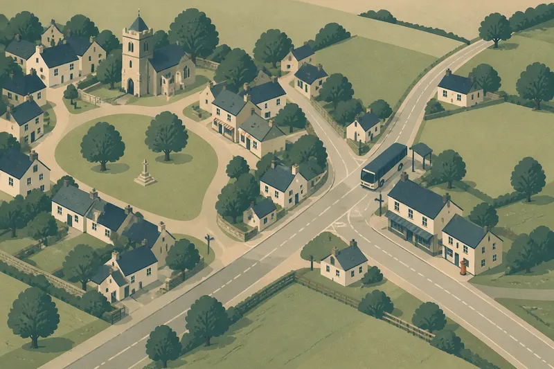
A settlement’s shape often reveals where everyday movement gathers. In a clustered settlement, homes and services collect around a shared center; in a linear one, they extend along a road or other route. Reading that difference can clarify how a place works without assuming that its outline tells the whole story.
Imagine a clearly hypothetical county hamlet called Alder Cross. At the start, its residents live in a compact group beside a small common, with a meeting hall and shop nearby. A county road passes along the edge, but most daily errands happen on foot within the cluster. Later, a regular coach route begins stopping at a junction beyond the hamlet, and a few services move beside the road. The resulting settlement stretches toward the stop. That change is not simply growth: it reflects a shift in where movement converges.
A center gives a cluster its everyday logic
A clustered settlement brings buildings close enough for shared destinations to organize daily life. The center might be a green, a market square, a churchyard, a school, a well, or simply the point where several lanes meet. Its importance need not come from formal design. Repeated use can make an unmarked widening in the road feel central.
The arrangement is legible in the short links between homes and common destinations. Side lanes tend to feed inward, while the center offers a place to pause, meet, trade, or change direction. A map may show a dense knot of buildings, but walking the streets gives a better sense of whether those buildings actually relate to one another or merely happen to stand close.
In Alder Cross, the common initially anchors the settlement because the hall and shop sit within an easy walk of the houses. The county road is present, but it does not yet organize the residents’ ordinary errands. The cluster therefore tells a story about local gathering, not isolation: people can still travel beyond it, but their shared destinations remain inside.
When reading a cluster, look for the places that draw several paths together, not just the most prominent building.
A route can pull activity into a line
A linear settlement forms when buildings and destinations follow a route. The route may be a road, a canal, a railway corridor, or another dependable passage, but the pattern alone does not establish which came first. A road can attract building, while existing homes and businesses can also make a route more useful and visible.
In a roadside settlement, front doors, shops, workshops, and public stops may face the same corridor. The resulting strip can have a recognizable main street, yet it may lack a single center. Instead, activity is distributed along the route, with each building relying on passing movement or on neighbors along the line.
Distance matters in a practical, local sense. Two destinations that look close on a map may sit on opposite sides of a difficult junction, steep grade, or busy road. Conversely, a longer-looking street may feel connected if its buildings face one another and people can move along it easily. The shape is a clue to the route’s role, not a substitute for noticing how people cross and travel.
Alder Cross begins to extend from the common toward the county-road junction once the coach stop becomes a regular destination. The newer buildings face the road, and the older lanes now lead toward the stop as well as inward to the common. The settlement has not simply become a line; it is developing a second organizing point.
Junctions can turn a line into a crossroads
A crossroads settlement gathers movement where routes meet. That meeting can support a compact center, a spread of buildings along several arms, or a mixture of both. What matters is not the geometry of a neat plus sign, but whether the junction gives travelers and residents a reason to stop, transfer, trade, or choose a direction.
The junction’s pull depends on what it connects. A crossing used mainly by through traffic may leave nearby homes dispersed. A crossing with a coach stop, store, public building, or convenient path into neighboring areas can become a destination in its own right. Multiple routes do not automatically create a community center; repeated local use gives the crossing its social weight.
In the invented Alder Cross situation, the coach stop makes the junction useful to people who previously had little reason to walk that way. A store relocates nearby, and a few homes appear between the common and the road. The old cluster remains recognizable, but daily movement now has two focal points: the common for local gathering and the junction for onward travel.
That is the walk-through’s central result. A settlement can combine forms as its routines change. The transition from cluster to crossroads is not a clean replacement of one pattern by another; older lanes and newer roadside buildings can remain part of the same place, serving different trips.
Read the settlement as a record of ordinary trips
Street patterns become more informative when paired with questions about routine movement. A map can suggest where paths converge, but observation should test whether those links still matter. Consider the location of everyday services, the direction buildings face, and the way side roads connect to the principal route.
- Find the apparent center and identify which lanes or streets lead toward it.
- Locate shops, schools, halls, transit stops, and other shared destinations; note whether they cluster or line a route.
- Check whether buildings face a road, a green, a junction, or a quieter lane.
- Notice where routes meet and whether the surrounding buildings make that meeting a destination or just a passage.
- Look for a break in the pattern, such as a newer roadside strip beside an older compact core.
- Compare the map with a visit or a reliable street-level view, paying attention to crossings and access rather than distance alone.
For example, if an invented hamlet has a tight group of homes around a green but its only shop sits at a nearby junction, the two features may serve distinct routines. The green can remain the social center while the junction handles travel and errands. Treating either as the settlement’s only center would miss how its parts connect.
Why can a settlement have more than one center?
Can a village be both clustered and linear?
Yes. An older cluster can sit beside a later ribbon of buildings along a road, especially when new destinations draw activity outward. The forms describe different parts or phases of a settlement rather than mutually exclusive categories.
Does a crossroads always become a settlement center?
No. A junction may carry traffic without offering a reason to stop or gather. Nearby services, access between routes, and regular local use help determine whether it becomes a center.
What can a map reveal about daily movement?
A map can show how streets converge, which buildings lie along a route, and whether the settlement has a compact core or an extended strip. It cannot, by itself, establish who uses those routes or how easy they are to cross.
Why might a settlement’s shape change?
New transport stops, services, or useful connections can shift where people make ordinary trips. Earlier patterns may persist, leaving a place with several linked centers rather than one dominant focal point.
Shape is evidence, not a complete explanation
Settlement form offers a useful starting point for understanding local connections, but it does not explain every cause. Buildings may remain after a service moves, and a street that once carried important traffic may now be quiet. A neat cluster on a map might also conceal barriers that divide its residents in practice.
Nor should a shape be treated as proof of a particular history. A line of buildings can suggest an association with a route, but the pattern alone cannot establish when it formed or why. Local records, signs, building uses, and careful observation can add context when those details matter.
For a reader tracing county settlements, the most useful question is often where everyday trips meet: at a shared center, along a route, or at a junction that links both. The distinction helps make sense of how a place connects inward and outward. In Alder Cross, the coach stop did not erase the common; it gave residents another reason to gather somewhere else.
When a settlement seems to have two centers, follow the ordinary destinations between them. The links may explain the shape more clearly than either focal point on its own.